After a strong backlash from Long Beach residents and neighborhood associations in August, Long Beach Development Services released new Land Use Element maps on November 10, reducing 686 acres of potential density through decreased building heights citywide, as part of the city’s General Plan.
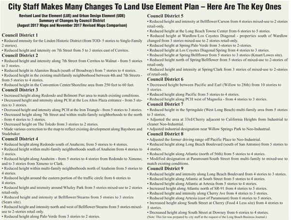
Revised maps released in August had caused an uproar from residents, especially those living in the 4th and 5th City Council Districts, over proposed building heights. Councilmembers Stacy Mungo and Daryl Supernaw, as well as Mayor Robert Garcia, agreed with the dissenting concerns, and the mayor asked the Long Beach Development Services Department to host four community meetings. At those meetings, residents voiced vehement opposition to the August maps. The new Land Use Element maps address some of the residents’ objections (refer to the adjacent list of major modifications).
“I hope that there is a recognition and an understanding that we heard what everybody was concerned about,” Director of Development Services Amy Bodek told the Business Journal. “But we also heard, over the last 18 months, a whole bunch of other people who wanted change. So, we had to balance that, and we also had to balance that with what we know are our needs for the future.”
Under the new maps, the 44% of Long Beach that is comprised of single-family neighborhoods will see no change. Another 19% of land includes the Long Beach Airport, the Port of Long Beach and other infrastructure, while 6% of the city is planned for mixed-use projects, including office, retail and residential. Five percent of land consists of existing multi-family residential buildings, and 5% of the city includes industrial or neo-industrial areas. The remaining 1% of the city is planned for traditional commercial or retail centers.
During the community meetings, some residents asked if additional meetings would be held once the newly revised maps were released. Bodek said her department would respectfully decline requests for meetings at this point, saying the department carried out the recommendations of the Long Beach Planning Commission in holding additional outreach, and further direction would be needed before city staff proceeded.
The State of California requires cities to maintain updated General Plans, and Long Beach has not revamped its policy since the 1980s. The updates are based on population growth estimates provided to cities by the state to the Southern California Association of Governments (SCAG), the nation’s largest metropolitan planning organization.
“I don’t think we will ever meet our needs but this is really a good step forward without creating downtowns everywhere, which is not what we want to do,” Bodek said. “Population growth, the projections that we are relying on, do show some incremental growth; but more importantly it is the accommodation of the people who are already here, who are overcrowded.”
Bodek explained that 12.2% of the Long Beach population is severely overcrowded. She said this number is “huge” and unacceptable on many levels. Between the 15,000 new residents who have settled in the city since 1989, as well as future projects, the city would need to build 28,000 new residential units, a number this plan does not accommodate.
The future projections by SCAG are based on census information and trends in population relocation; however, Bodek said the city contested the allocation of housing units requested of Long Beach. She explained that other cities received larger reductions in projections than Long Beach, partly due to inaccurate 2010 census data resulting from undercounting.
Between the state’s concerns about dealing with the current housing crisis and the concerns of Long Beach residents, Bodek said she thinks her department did its best to find a balance, which requires compromise on all sides. However, some residents in largely residential districts voiced the opinion that density and increased population belongs in the downtown area and that their communities should not be affected in any way.
“The downtown makes up approximately 2% of the city. As much as we would like to concentrate development in the downtown, that’s not really feasible,” Bodek explained. “There are huge chunks of land that we’re really not touching throughout the whole city and there are smaller areas where we feel we can effectuate change to deal with some of the population and housing and job growth that we expect to see in the next 20 to 30 years.”
Despite some resident pushback to any population growth in the city, Advance Planning Officer Christopher Koontz explained that the city must attempt to also accommodate for job growth as it continues working to attract business. He added that, while the Land Use Element maps are the “main event” that drew resident attention, a companion proposal is also up for approval.
“The companion piece to this is the Urban Design Element, which is having actual design standards for new development, which we currently do not have,” Koontz said. “We are trying to move away from just regulating how tall or how many units, but what is it actually going to look like, and is it going to work with the street and have a consistent distance from the sidewalk?”
A feel-good story being overlooked is the new possibility for new investments in portions of Council Districts 8 and 9, according to Koontz. He explained that current zoning does not promote investment in what are currently underserved and marginalized areas. He said the new Land Use Element would be an incentive for developers to enter these areas, making them cleaner and safer for residents.
The updated maps, along with reports of resident feedback are scheduled to be presented to the planning commission during its December 11 meeting, according to City Manager Patrick West.
“We went through the experience. The development services team has been doing this for quite some time,” West said. “And then we had the four meetings and they were painful, but we listened and paid attention at those meetings.”
In response to the new maps, Councilmember Mungo is hosting three community meetings: Tonight, November 21, in Cirivello’s Barrel Room, 4115 N. Viking Way, from 6:30-8 p.m.; Monday, November 27, in the Millikan High School cafeteria, 2800 Snowden Ave., from 6:30-8 p.m.; and Wednesday, November 29, in the El Dorado Senior Center Bridge Room, 2800 N. Studebaker Rd., from 6:30-8 p.m.