In response to resident pushback on proposed Land Use and Urban Design elements as part of the General Plan, Long Beach Development Services announced a series of four additional community meetings to gather community feedback.
“I think more input is always a good thing, and it helps us learn. And it helps a really good plan become an even better plan,” Christopher Koontz, advance planning officer for the planning bureau, said. “So I’m glad to go through the exercise. And it gives us a chance to communicate not just with the folks that were in the room there but with a lot of people, and to educate them and get their input and be able to move forward even better than where we were before.”
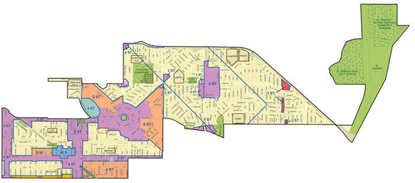
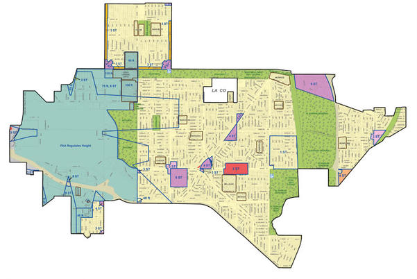
During the Long Beach Planning Commission meeting on August 17, new district maps were presented showing proposed building heights. During public comment, residents – namely from the 4th and 5th districts – voiced their displeasure and concerns regarding the proposed building heights and increased density in their mostly single-family home districts.
4th District
5th District
Development Services Director Amy Bodek said city staff would take the new maps to city council in early October as planned, regardless of the decision made by the planning commissioners at the meeting. This drew much scrutiny from residents who felt their input and concerns were being ignored.
On August 18, Mayor Robert Garcia released the following statement:
“The Land Use Element is an important community document that will guide development and building across Long Beach for decades to come. City Staff has been working very hard on presenting their recommendations to the community and the planning commission. It is important that there is adequate community input before the Land Use Element is presented to the city council.
“I support the Planning Commission’s recommendation for more community input and have asked staff not to present the Land Use Element to the city council until there has been more community input over the next couple of months. In addition, I have asked staff to go back to the planning commission after additional public input has been received to make a recommendation for consideration by the city council. I don’t intend to schedule a city council hearing on the Land Use Element until the additional public comment period and planning commission recommendations are finalized.”
The latest maps were the result of a February planning commission meeting in which Wrigley residents voiced similar concerns of increased density in their area. Original height proposals focused most of the density in the downtown and Wrigley areas near the Metro Blue Line. The result of that meeting was a request to disperse density throughout the city and for more outreach to residents in the Wrigley area who felt left out of the decade-long process.
“There have been over 100 meetings over the years,” Koontz said. “There have been citywide open houses, online outreach and conventional outreach. So that’s all occurred over the preceding decade.”
According to the August 25 community meeting press release, more than 30 public meetings and presentations about the Land Use Element have been held across the city in the last 18 months alone.
Now, after four community meetings and two study sessions between the February and August meetings, the new maps have merely transferred concerns to residents in other districts across the city.
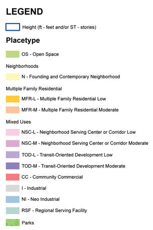
In District 4, around the traffic circle and along Pacific Coast Highway and Anaheim Street, much of the space has been designated between four and six stories for multi-family, low-income residential housing and moderate neighborhood serving centers or corridors. Several other small pockets in the district were designated between three and five stories.
Throughout District 5, several small areas were designated between three and five stories, with the Long Beach Towne Center being designated six stories. The majority of increased building height allowances are at commercial centers, such as the corners of Bellflower Boulevard and Spring Street, Los Coyotes Diagonal and Spring Street, Los Coyotes Diagonal and Palo Verde Avenue, and Spring Street and Palo Verde.
Fifth District Councilmember Stacy Mungo did not respond for comment on the proposed maps and subsequent commission decision. However, on August 18, the councilmember tweeted, “I am requesting we return to the original plan use maps and am supporting the planning commission in their recommendation for more input.”
Fourth District Councilmember Daryl Supernaw told the Business Journal that he also fully supports the decision of the planning commission and the mayor to hold additional community meetings in various districts, including his own. He noted that aside from hearing from the public, the community meetings would clear up misinformation about the proposals.
“We just want to hear what the public has to say about this. On the surface, the concerns will be on parking and the transportation corridors,” Supernaw said. “Aside from hearing from the residents, we want to get the information out there as to what is being proposed.”
Among the misinformation being spread on websites such as Nextdoor is the idea that the maps show a plan of actual future development in which the city could utilize eminent domain to take identified properties, such as churches, to build high-density housing. However, Development Services Communications Officer Kevin Lee pointed out that the maps are merely what would be permitted at properties if they were to be redeveloped in the future.
“Building height has definitely been a concern of some residents. There have also been some concerns about mixed-use and new development outside of the downtown area,” Lee said. “Most parcels actually will not change. Some will over time. Leases could be moved out depending on the terms of their lease, [but] property owners can choose to redevelop or not.”
Essentially, the property owner, not the city, would determine if and when an identified parcel would be redeveloped.
Lee agreed with Supernaw that the newly announced community meetings will serve to better educate residents on the Land Use Element, as well as allow the city to address residents’ specific concerns.
The upcoming community meetings are scheduled as follows:
• Saturday, September 30, 3 p.m., Veterans Park Community Center, 101 E. 28th St.
• Wednesday, October 4, 6 p.m., Whaley Park Community Center, 5620 E. Atherton St.
• Saturday, October 14, 11 a.m., Best Western Golden Sails Hotel, 6285 Pacific Coast Hwy.
• Wednesday, October 18, 6 p.m., Expo Arts Center, 4321 Atlantic Ave.
Additionally, residents can view plan information, comment and give feedback online by visiting www.longbeach.gov/lueude2040. According to Koontz, the city staff hopes to return to the planning commission before the end of the year.